|
Introduction
Nevada is much more than mining, gambling, buckaroos and vast desert country. It is a region of climatic extremes, a land where surface temperatures have
soared to a sizzling 125º (June 1994) or plunged to an Arctic-like 50º below zero (January 1937). Nevada is characterized by isolated, long, narrow, roughly parallel mountain ranges and broad, intervening, nearly
flat valleys and basins. The spectacular magnitude of alternating mountain ranges and valleys prompted the term "Basin and Range Province," a designation that includes most of Nevada. The climate of the Silver State
is
|

|
|
Special thanks to Nevada State Climatologist John James for his generous and professional assistance in compiling these data.
|
|
characterized as semi-arid to arid with precipitation and temperature varying widely between the northern and southern regions of the State as well as
between the valley floors and mountaintops. Temperatures can fall below minus 40º during winter in the northeastern region, and rise to over 120º during summer in the south. Precipitation ranges from barely
three or four inches in southern Nevada to more than 40 inches (and over 300 inches of snowfall) in the Carson Range portion of the Sierra Nevada.
Few places in the world boast seasonal temperature swings of 175º Fahrenheit, but Nevada is certainly more unique than that. The Silver State
has more mountain ranges than any other state except Alaska,
 |
and ranks third in seismic activity behind Alaska and California. It is also the
most parched in the Nation. Nevada may be dry and dusty today, but more than 200 million years ago the region was actually the floor of an ancient
equatorial sea. At that time the west coast of the continental United States was near the western border of the State of Wyoming, and a continental
shelf covered much of eastern Nevada and western Utah with deep ocean stretching from central Nevada westward. Sixty-foot-long prehistoric sea
-lizards that thrived in the warm, equatorial waters of this ancient sea were later stranded in shallow mud flats as the land mass gradually rose and the
water receded. These giant creatures, named Ichthyosaurs, were trapped and then died. After reigning the world's oceans for about 135 million years,
the remains were buried under thousands of feet of sediment and fossilized. Over time the region was thrust violently upward to 7,000 feet above sea
level, where in 1928 the fossilized remains of Ichthyosaurs were discovered. In 1977, some 200 million years after its entombment, Ichthyosaurus Shonisaurus popularis, named after the mountain range in which it was
discovered (Shoshone), was immortalized as Nevada's official state fossil.
The Nevada we know today has existed for only the last few seconds of the
total geologic clock of time. As recently as 10,000 years ago the region was considerably wetter than now and much of the land was covered with ancient
lakes and expansive, lush grasslands that formed during the last Ice Age. One of the largest of these lakes was prehistoric Lake Lahontan, which
extended for over 8,600 square miles and covered an irregular series of basins in northwestern Nevada. Even larger was Lake Bonneville, which at
its peak extended for nearly 20,000 square miles and covered most of northwestern Utah and extended into northeastern Nevada and southern
Idaho as well. As the climate became warmer and drier, the massive North American ice sheets receded northward toward the polar ice cap. The
receding ice sheet dramatically changed Nevada's climate, wiping out entire animal species and withering the abundant vegetation. The region's water
resources became isolated primarily in shrinking desert lakes or locked beneath the sedimentary layers of the State's numerous elongated valleys.
Total average precipitation in Nevada runs about 9 inches per year, making
the Silver State the driest in the Nation.* Located within the arid Great Basin and on the lee side of the towering Sierra Nevada range, little maritime moisture reaches the State. The lofty peaks of the
|
|
|
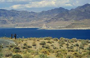
Pyramid Lake, terminus of the Truckee River, is a relic of prehistoric Lake Lahontan.
|
|
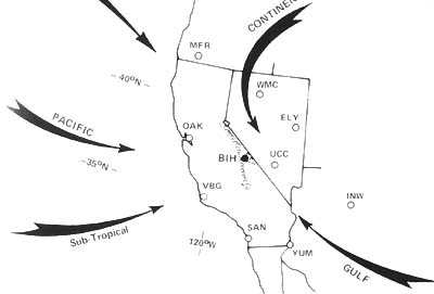
Sierra, which stretch along much of Nevada's western border, interrupt the prevailing easterly flow of moisture-laden winter storm
systems that frequently roar in from the Pacific Ocean. The resultant "rain shadow" has desiccated the landscape. Some of the lower elevations receive less than four inches of precipitation annually while
average lake surface evaporation rates can exceed more than 80 inches a year. Due to these high evaporation rates and lack of incoming moisture, the few
rivers that do exist in Nevada end in sinks, not lakes. River drainage flows to enclosed basins rather than to the sea. Of the total annual average
precipitation, only 10% contributes to stream runoff and ground-water recharge. The remaining 90% is lost through evaporation and transpiration.*
This article has been broken into five sections for your convenience:
**This website has more on Nevada climate and precipitation.
Here is more on Nevada topography and hydrogeography.
|

